Callington
OS grid ref:- SX 3569
 The small town of Callington is situated about 7 miles (11 km) to the north of Saltash and about 14 miles from Plymouth and lies between Dartmoor to the east and Bodmin Moor to the west.
Originally a Saxon settlement, it is mentioned in the Domesday Book of 1086 as Calwetone. Callington was once a mining town, in the eighteenth century, it was one of the most important mining areas in Britain, but nowadays, farming and tourism have become its major industries. Busy Fore Street is the towns main shopping centre.
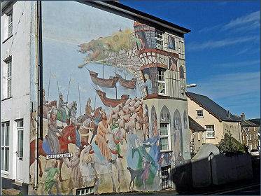
The Old Clink is a vestry room in the town with two small rooms, where petty criminals were once detained while awaiting the arrival of a visiting magistrate. The Callington mural (above left) is the work of professional and amateur artists depicting Callingtons landscape and rich heritage. Rounding every corner shows attractive colorful murals that has become Callingtons spotlight. Callington Museum and Heritage Centre is situated in the former chapel building on Liskeard Road, It opened on 2nd June 1994 and since then has attracted over 7,000 visitors. Its exhibits span all aspects of the social and economic history of Callington and its surrounding parishes.
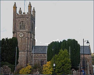 Granite St Marys Church, dating to the fifteenth century, (it was consecrated in 1438) stands at the centre of the town and is reputed to have been built by Sir Nicholas Assheton. It was originally a chapel of ease to South Hill. The building has a battlemented porch with an eighteenth century sundial and a fifteenth century tower with pinnacles springing from angels. A Celtic lantern cross stands in its churchyard as well as the ancient tombs belonging to the Willoughby and Ayssheton families.
There are a number of tombs in the church, two of which are of note, the first is that of Sir Nicholas Assheton, who had been a judge and whose portrait is in the chancel floor. The second is of a knight, Robert Willoughby the first Lord Willoughby de Broke (pictured left) , who fought on Bosworth Field at the birth of the Tudor dynasty in 1485, and was a Marshal in the army of Henry Tudor, Earl of Richmond, who after the battle became King Henry VII. He had been steward of the Duchy of Cornwall and died at the manor house of Callington in 1502.
Kit Hill Country Park dominates the skyline for miles and boasts ideal picnic spots, footpaths for enjoyable walks, as well as ancient mine workings. Kit Hill rises to to 333 metres (1,093 feet) high it was given to the county by Charles, Prince of Wales in 1985 to mark the birth of Prince William. The word 'Kit' derives from Old English for Kite, a reference to birds of prey. As the highest point of Hingston Down, Kit Hill is probably the best viewpoint in the southeast of Cornwall, with spectacular views over Bodmin Moor, the Tamar Valley and Dartmoor in Devon.
The Anglo-Saxon Chronicle records that in 835, Egbert king of the West Saxons defeated an army of Vikings and Cornish at Hengestdun = "Stallion Hill", which is usually interpreted as being at Hingston Down. The Danish fleet is thought to have arrived at Plymouth Sound in 838 and this is still commemorated in the annual Viking parade in nearby Calstock, where locals dressed as Vikings row up the river to Danescombe, thought to be one of the sites of the landing of the Danish boats.
Callington has been suggested as one of the possible locations of the ancient site of Celliwig, associated with King Arthur, Celliwig is perhaps the earliest named location for the court of King Arthur. It may be translated as 'forest grove'. Nearby ancient monuments include Castlewitch Henge with a diameter of 96m and Cadsonbury Iron Age hillfort.
Dupath Holy Well, the largest and most impressive Well House in Cornwall, is situated a mile to the east of the town. The granite well house is built over a natural spring and has a steeply-pitched corbelled roof. Weathered pinnacles are situated at each corner and a small bell turret, with a highly elaborate canopy, stands over the entrance. It was once believed that the holy water from this well was able to cure the whooping cough.
ead2.googlesyndication.com/pagead/show_ads.js">