The Cornish Riviera
 The Cornish Riviera is a green and gold tapestry of wooded hills sloping down to secluded coves that hide picturesque enchanted fishing villages and pilgrim trails that wind past sleepy farms and ancient stones.
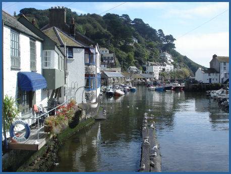
The picture postcard village of Polperro (pictured left) has the reputation of being one of the loveliest fishing villages in Cornwall, with characterful streets of colourwashed cottages sheltered in a cliff ravine which descends to a picturesque harbour.
Many of Polperro's streets are so narrow that cars are banned from the village and visitors must walk down or ride on a horse drawn carriage from the main car park above. A brook flows through the village down to the harbour. Polperro was once a thriving centre for smuggling and is still a working fishing village.
The nearby village of Lansallos is of ancient origin, Lansallos is mentioned in the Domesday Book as the manor of Lansalhas and was owned by Robert, Count of Mortain, the half-brother of King William the Conqueror. The village takes its name from a monastery dedicated to St Salwys.
Ince Castle is situated three miles (5 km) from the town of Saltash. The brick manor house was built in 1642, at the start of the Civil War. The house stands on a peninsula by the River Lynher, from which its name derives from the Cornish enys, meaning island, it faces Antony House. The first house to occupy the site was possibly built by the Courtenay family in the late fourteenth century. It later came into the possession of the Killigrews who totally remodelled the house. Ince Castle is laid out as a rectangle with four square corner towers each four storeys high. Local legend states that Henry Killigrew, the Royalist MP for West Looe, kept four wives, one in each tower, each unknown to the others.
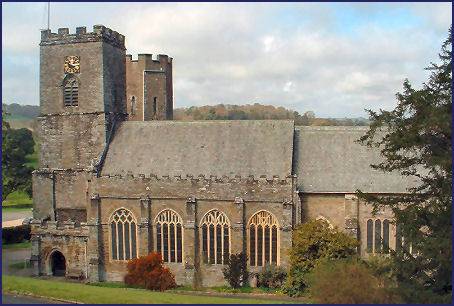 Historic St. Germans Priory Church, (piuctured right) is dedicated to St Germanus, a fourth to fifth century bishop of Auxerre, became Cornwall's Cathedral in
926, when Conan was created the first Cornish bishop by the Saxon King Athelstan. The present church, which was erected between 1160 and 1170, occupies the site of the Saxon Cathedral.
Historic St. Germans Priory Church, (piuctured right) is dedicated to St Germanus, a fourth to fifth century bishop of Auxerre, became Cornwall's Cathedral in
926, when Conan was created the first Cornish bishop by the Saxon King Athelstan. The present church, which was erected between 1160 and 1170, occupies the site of the Saxon Cathedral.
The seat of the Eliot family, Port Eliot is situated by the priory. The house stands on the banks of the Tamar estuary system, the Port Eliot estate lies 10 miles to the west of Plymouth. The house has roots as ancient as the fifth century , making it one of the oldest buildings in continuous habitation in Britain.
Nearby Dupath Holy Well the largest and most impressive Well House in Cornwall, probably dates from 1510 and was built by the Augustinian canons of the priory.
The dramatic ruins of a fifteenth century chapel surmount the volcanic upthrust of grainte known as Roche Rock. Many myths and legends cling to this atmospheric site. Situated around six miles from St. Austell and eight miles from Bodmin, the chapel is dedicated to St. Michael. Roche Rock (pronounced Roach) has long been a significant local religious centre.
Restormel Castle dramatically bestrides a hill top overlooking the River Fowey around a mile to the north of Lostwithiel and 9 miles north east of St. Austell. The castle was founded by Robert, Count of Mortain, the half brother of William the Conqueror. It occupies the site of an earlier wooden Norman fort.The stone structure we see today dates from around 1200.
Restormel was once home to the famous Edward, the Black Prince, who, as eldest son of King Edward III, was also Prince of Wales and Duke of Cornwall. Trematon Castle is is of similar design to Restormel, situated two miles southwest of the town of Saltash and occupying an emminence rising steeply from the River Lynher, it overlooks Plymouth Sound.
 Beautiful Whitsand Bay, (left) runs from Rame Head in the east to Portwrinkle in the west. The bay is characterised by sheer, high cliffs, dramatic scenery and long stretches of sandy beaches. The village of Portwrinkle has a small harbour and two beaches are accessible from it. The two sand and shingle beaches have numerous rock pools, A National Trust property at Sharrow Point preserves a small cave excavated by hand in 1874 by a hermit called Lugger, who inscribed verses on the ceiling to relieve his boredom. Lugger's Cave is fenced off to the public.
Whitsand B ay is overlooked by Rame Head, on top of which are the ruins of a fourteenth century chapel dedicated to St Michael. is a part of Mount Edgcumbe Country Park which is jointly owned and run by Cornwall Council and Plymouth City Council. Panoramic views are to be had from the summit, to the west along Whitesand Bay and east towards Plymouth Sound. 400 feet high cliffs slope into the sea while Dartmoor ponies graze around the head. The area is also inhabited by deer. There is a National Coastwatch look-out station at the head which is staffed by volunteers.
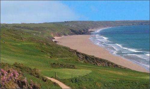
Stunning Talland Bay lies between the villages of Polperro and Looe on Cornwall's eastern coast. 'Tallan' in Cornish means 'holy place on the brow of a hill'. The bay was once well known as a landing spot for smugglers and the village has its share of smuggling stories.
The highly attractive adjoining small fishing villages of Kingsand and Cawsand lie on the Rame Peninsula and are known as "Cornwall 's Forgotten Corner". The villages date mainly from the seventeenth century and lie sheltered by a wooded headland at the mouth of Plymouth Sound. The villages are only a short walk apart and the surrounding scenery is spectacular. The spectacular and dramatic coastal headland of Rame Head is known in Cornish as Penn an Hordh and lies to the southwest of the village of Rame in southeast Cornwall. The headland was once referred to as Pen den har, which is understood to derive from the Cornish meaning fortified rock promontory or headland.