South Cornwall
 The spectacular coastline of South Cornwall with its hidden coves, wealth of sandy beaches and characterful harbour towns and villages has something for everyone.
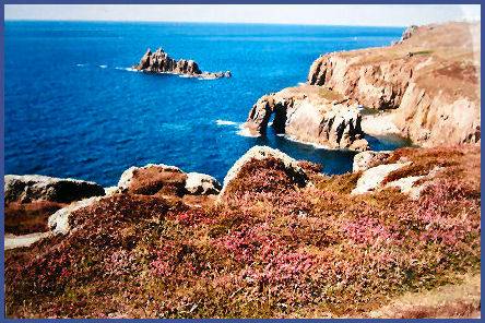
Land's End, (pictured left) with its dramatic crashing waves which lash the rugged Cornish cliffs, is the most westerly point in England and one of the most visited places in the county of Cornwall. The stunning scenery of Land's End has made it one of Britain's favourite destinations and one of the country's most magnificent and enduring landmarks.
Lands End has inspired people since the time of the ancient Greeks, it was known to the Romans as 'Belerion' meaning the sea of storms, while it is known in the Cornish language as Penn an Wlas or Pedn an Wlas, meaning 'the end of the earth'.
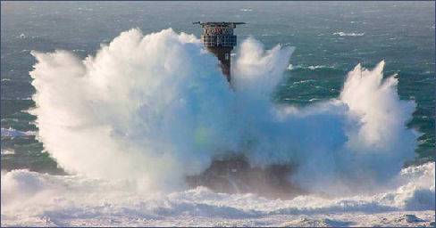 The stunning beauty of legendary Land's End is witness to the force of the Atlantic waves. The Longships Lighthouse (right) stands solitary beyond the granite grandeur of the cliffs about a mile out to sea, the current lighthouse is the second tower to be built on the rocks and has been unmanned since 1967. Grey seals often bask there.
Nearby Cape Cornwall is situated at the point at which Atlantic currents divide, either going south towards the English Channel, or north into the Bristol Channel and rivals its neighbour Lands End in natural beauty. The Scilly Isles can be sighted from the cape on a clear day.
The archetypal Cornish village of Mousehole boasts what is said to be one of the most beautiful harbours in Britain. Once a thriving centre for the Cornish pilchard fishing industry. Its narrow streets are filled with small shops, galleries and restaurants, while its granite cottages progress quaintly down the steep hillside to the waters edge. Pronounced 'Mauzel' the name possibly derives from the Cornish 'mouz bel' or maiden's brook. The last recorded speaker of the ancient Cornish language, Dorothy or Dolly Pentreath, was a native of Mousehole and died there in 1777 at the age of 102. Her grave can be seen in the churchyard of Paul on the hilltop above the village. Dolly was born in 1692, the daughter of Nicholas Pentreath, a fisherman. She lived in the parish of Paul, next to Mousehole.
The moors of South Cornwall are littered with ancient monuments Chysauster Iron Age Village, at Gulval near Penzance was inhabited from around 100 B.C to the third century A.D. It was probably built by members of the ancient Celtic Dumnonii tribe, who then inhabited the area. The village, which is now in the care of English Heritage, has nine courtyard houses, with a further house lying just beyond. The Iron Age promontary fort of Treryn Dinas or Treen Castle is situated on a narrow granite headland between Penberth Cove and Porthcurno.
Other prehistoric sites of interest include the Men an Tol standing stones and the Merry Maidens Stone Circle, a stone circle which dates from the Bronze Age, which is the best preserved circle in Cornwall. The moorland villages of Sancreed and Madron both possess ancient holy wells, where the pagan tradition of hanging cloughties (small strips of cloth) on the surrounding trees to ward off evil spirits is still practiced..
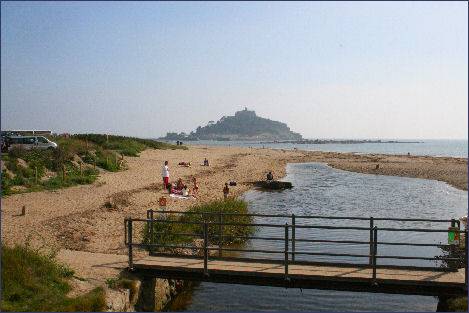 St. Michael's Mount (left), England's most scenic coastal attraction, occupies a granite outcrop which rises dramatically from Mount's Bay and is a medieval castle with sub tropical hanging gardens and a church perched on top of a rocky island, cut off from the mainland at high tide. The mount has been a trading place for tin since the Iron Age and was known to the Greeks and the Romans. According to one legend St Michael is believed to have appeared there in AD 710.
A Saxon Reilgious settlement may have existed on the Mount in the reign of Edward the Confessor
St. Michael's Mount (left), England's most scenic coastal attraction, occupies a granite outcrop which rises dramatically from Mount's Bay and is a medieval castle with sub tropical hanging gardens and a church perched on top of a rocky island, cut off from the mainland at high tide. The mount has been a trading place for tin since the Iron Age and was known to the Greeks and the Romans. According to one legend St Michael is believed to have appeared there in AD 710.
A Saxon Reilgious settlement may have existed on the Mount in the reign of Edward the Confessor
The island, which can claim to be Cornwall's most celebrated landmark, can be reached via the causeway at low tide, a boat service operates across from the characterful town of Marazion at times of high tide.
Picturesque Lamorna Cove has been popular in the past with artists, craftsmen and potters, the artist Samuel John Birch loved the place so much he even added Lamorna to his name. In the late nineteenth and early twentieth centuries Lamorna became popular with artists of the Newlyn School. 'Lamorna' Birch lived there from 1908.
Sennen Cove lies a mile (1.5km) northeast of Land's End, sheltered by the headland of Ped-men-du, the cove nestles in the southeast corner of Whitesand Bay and is a popular spot with surfers. Once a pilchard fishing station, there is a harbour and beach, where pleasure boat cruises operate regularly. Secluded Prussia Cove or Porth-en-Alls as it is known in Cornish, lies to the east of Cudden Point on the coast of Mount's Bay. The cove has a famous history of smuggling and was one of the foremost locations for landing and storing contraband. This is mainly due to the actions of the notorious John Carter, an eighteenth century smuggler who operated from the cove and was known as the King of Prussia.
Britain's longest trail, the South West Coast Path stretches for 630 miles (1, 014 km) from Minehead, on the edge of the Exmoor National Park, along the coasts of Devon and Cornwall to Poole in Dorset. The path is an excellent way to see Cornwall's superb coastal scenery, wildlife and unique heritage