St. Just-in-Penwith
OS Grid ref:- SW3731
 The small town of St. Just in Penwith in the far west of Cornwall is the nearest town to Land's End.
The town has been a prosperous mining centre since Medieval times and experienced a boom during the Industrial Revolution during the nineteenth century St. Just was one of the most important mining districts in Cornwall both for copper and tin and deserted and disused engine houses dominate the landscape in the area.
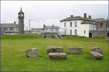
In the town square, near the clock tower stands the ancient 'plen-an-gwary', (pictured left) Cornish for playing place, where the Medieval mystery plays were once performed. The Plen An Gwarry is over six hundred years old probably the oldest working outdoor theatre in Britain, it is now used for choosing St. Just's Carnival Queen and is central to the celebrations of the annual Lafrowda Day festival. There is evidence to suggest that Bartinney Castle near Sancreed in the Penwith Peninsula may have been an Iron Age Plen An Gwarry for the celebration of Celtic Fire festivals.
 St. Just has many old grey stone terraced cottages and a large fifteenth century granite church which has an interesting medieval wall painting of St. George and the dragon (pictured right). There are actually two medieval wall paintings inside the church, but both have been heavily restored; the other depicts a warning to breakers of the Sabbath.
The Selus Stone, situated in the north aisle, is a three foot high pillar which was discovered around 150 years ago. It is thought to date from the late fifth or early sixth centuries and bears a Greek monogram and the Latin inscription Selus Ic Iacet (Selus lies here). This is thought to refer to Salomon of Cornwall, otherwise known as Saint Selevan.
The two storey Methodist church and Market House are also built of the local stone. The village has a profusion of galleries, the King's Arms inn, which stands next to the church, dates from the fourteenth century.
The St Just feast is held in November each year to celebrate the dedication of the parish church. The feast itself is a two-day long event which includes a church service and civic procession being held on the Sunday of the feast and a larger scale popular celebration being held on the Monday.
The Tinner's Way an ancient trackway, runs from St. Just to St. Ives, and passes the prehistoric remains of Chun Quoit and Chun Castle as well as many old abandoned tin mines. From Cape Cornwall, the Tinner's Way passes through St. Just on its way to the moors and granite outcrops of the the north west coast of the Cornish peninsula. It passes many ancient points of interest including Men-an-Tol and Bodrifty Iron Age Village.
Nearby Carn Kenidjack (OS grid reference SW 388 329) at Tregeseal, has a number of megaliths including Tregeseal East stone circle. A local legend tells how two miners returning home one night witnessed a wrestling match near Carn Kenidjack, which was presided over by the Devil. When one of the demon wrestlers was wounded, they whispered a prayer in his ear, and the entire spectacle is reported to have disappeared.
A walk from St. Just in Penwith
Distance 5 miles
Duration - around 3 hours
*Commencing at the large car park at St. Just-in-Penwith, proceed along the footpath beside the churchyard gate across the square.
*On reaching the road at Nancherrow Farm follow the narrow path on the left that runs down the Kenidjack Valley to the sea. Follow the coastal footpath which is signposted to the right, passing the ruined mines of Botallack and Levant.
*From Levant trace your steps to return to St. Just.
Towns and Villages of Cornwall