Talland Bay
Os Grid ref:- SX 224 515
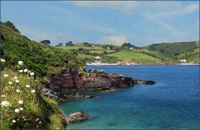 Stunning Talland Bay lies between the villages of Polperro and Looe on Cornwall's eastern coast. 'Tallan' in Cornish means 'holy place on the brow of a hill'.
There are two principal beaches in Talland Bay, both are quite small , the western beach, adjacent to the Talland Beach cafe, is the most popular with familes. It has sand both at high tide and low tide and is good for swimming at both high and low tides. At low tide there are rock pools teeming with sea life. There is limited car parking near the sea, there is a small and free car park adjoining the beach near Smugglers Cottage, and a pay and display car park at The Beach Café.
 The bay was once well known as a landing spot for smugglers and the village has its share of smuggling stories. The Rev Richard Dodge, who at the start of the eighteenth century was often observed leaping around the churchyard at night, cracking a whip around the headstones to drive away evil spirits. It has been suggested that the clergyman's eccentric behaviour was actually a cover to keep prowlers away from the churchyard while the smugglers were bringing their cargo through. The so-called 'Battling Billy', used a hearse to convey his kegs of brandy inland, knowing that the Customs men were unlikely to search a coffin for smuggled goods. Legend states that after he was shot by the Revenue men, his corpse went on to drive the hearse over the cliffs despite the gunshot wounds to his neck. Locals say that his spirit still haunts the bay on windy nights.
Talland Bay has also been the scene of many shipwrecks including that of a French trawler, the Marguerite, in March 1922. Two private boats performed a dramatic rescue and all 21 people were saved. The remains of the ship's boiler can still be clearly seen on the beach at low tide
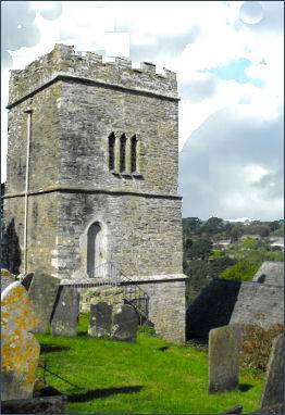
The ancient church of St. Tallanus perches dramatically on the cliff tops. St Tallanus is said to be a hermit who made his home here sometime in the fifth century, the site has been a sacred place since Celtic times. The altar of the present-day church, said to date from the time of Tallanus, is situated on the site of the original Celtic altar.
Part of the nave and the first stage of the tower probably remain from a thirteenth century church, the remainder, in the Cornish Perpendicular style, probably dates to the late fifteenth century. Inside the church is the headstone of Robert Mark who was killed in 1802, some accounts state that he was a Polperro smuggler shot at sea, others that he was a revenue collector killed on duty. The building has fine wagon roofs, the benchends date partly to circa 1520 and the remainder circa1600.
The South West Coastal Path passes through Talland. Eastwards, between Talland Bay and Hannafore, near Looe (3 miles) the coastline is unspoilt. Travelling west, between Talland Bay and Polperro (1.5 miles) the coast path passes by unspoilt cliffs and over downs.
A walk to Talland Bay from Polperro
Distance- 3.7 miles (6.0 km)
(1) From the Crumplehorn car park proceed down into Polperro village. On reaching Fore Street continue to the bottom of Talland Hill. Turn right into Talland Street then continue along The Warren, around the north side of the harbour.
(2) Folow the path as it climbs steeply uphill passing the viewpoint. Continue along the South West Coast Path reaching a fork in the path at the top take the route around Downend Point to Talland, ignoring the inland footpath inland to Brent and the lane on the left just before reaching Talland Bay.
(3) Turn left at Bridals Lane above the first beach and follow the lane through the trees around the base of the hill, cross a stream and then ascend to the road at Carey Park, above Polperro.
(4) Cross the road and continue along the lane ahead. On reaching the bottom of the lane, turn right as indicated by the sign to the village. Continue over Talland Hill back down to Polperro harbour and from here retrace your steps to the car park at Crumplehorn.