St. Anthony Head
OS grid reference - SW 846 311
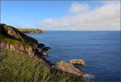 St Anthony Head lies at the southernmost tip of the Roseland Peninsula, around 16 miles from Truro, it guards the entrance to one of the world's great natural harbours, and offers commanding views of the Fal estuary. There are two sandy beaches at the head, Great Molunan and Little Molunan, they lie to the north of St Anthony Head, with fine sea views over the Fal Estuary and Carrick Roads.
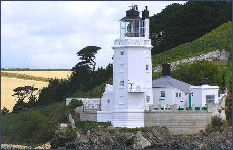
The granite St Anthony lighthouse was constructed in 1835 by the chief engineer of Trinity House, James Walker. It watches over the mouth of the Fal River and Carrick Roads and warning passing ships of the infamous Manacles rocks.Even in the seventeenth century rudimentary navigational aids were employed at St. Anthony's Head. The Killigrew family flew a large red flag from an elm tree to mark the wind direction, however this was eventually taken down in 1779 to avoid its being used by invading fleets.
Although automated since 1987 the light house is often open for visitors during the summer months. The lighthouse featured in the UK version of Fraggle Rock, as "Fraggle Rock Lighthouse" in external scenes. Nearby St. Mawes also featured in some scenes from the programme.
 The South West Coastal Path traverses the headland and there is a variety of wildlife to be seen from the birdhide.
Fulmars are often sighted and visitors may also catch sight of shags congregating on the low rock near the lighthouse. Grey seals are frequently seen on the rocks.
The South West Coastal Path traverses the headland and there is a variety of wildlife to be seen from the birdhide.
Fulmars are often sighted and visitors may also catch sight of shags congregating on the low rock near the lighthouse. Grey seals are frequently seen on the rocks.
St Anthony Head had a gun battery from the early ninteenth century until 1957. It's commanding views of the Fal estuary made it an ideal observation point for looking out for enemy shipping. When the National Trust acquired St Anthony Head in 1959, some of the more unsightly military installations were removed. A small house at the entrance to the car park was once the fort's guard room. The working battery is mostly underground, and below the gun emplacements a door leads down to the magazine, which was the storage place for amunition. There is also a restored Battery Observation Post, built during the Second World War to identify enemy ships.
A birdwatching hide is situated on the headland, the rocks which lie offshore of the lighthouse are a favourite roosting spot with sea birds. A small National Trust car park is situated at St Anthony Head.
Directions
Aproaching from the east or west on the A390, about 4 miles east of Truro turn onto the A3078 for St Mawes. Continue on the A3078 until Trewithian. At Trewithian turn left for Portscatho. Continue on this road though Gerrans and past Porth Creek and Porth Farm. Then take a left turn and follow this road to St Anthony Head
A Walk at St Anthony Head
Distance- 3.5 miles
Duration - 2 hours
(1) Commencing from Place ferry when you arrive at Place turn right, take the gate on the right to the small quay and turn left to pass the gates of Place House. At the first footpath on your right go into the churchyard. Take the steps in front of the church door up and it veers to the right.
(2) Turn right and follow the path with Place House now on the right. Continue along the path to Cellars Beach. Walk up hill and pass through a kissing gate at the top. Take the path diagonally down to the left and not the path along the top of the field immediately left. The path follows the edge of the entrance to the Carrick Roads with views across to the town of Falmouth.
(3) As the path flattens out into a field there is a path that runs down to the edge of the field. continue down to Great Molunan beach. From the beach retrace your steps to the path and head right towards the St Anthony's lighthouse.
(4) Continue up the slope to your left and continue up to the car park and café. Turn right and follow the path along coastline to Porthbeor Beach. There is a descent and ascent before it levels out in a field.
(5) 200 metres after the granite stile there is a footpath sign with steps leading down to the beach. With the steps behind you walk up to the stile at the hedgerow behind which is the road. Turn left and walk onto the T-junction, which will take you uphill to the left to St Anthony's Head or right down to Place House.