Zone Point
OS grid reference :- SW 8430
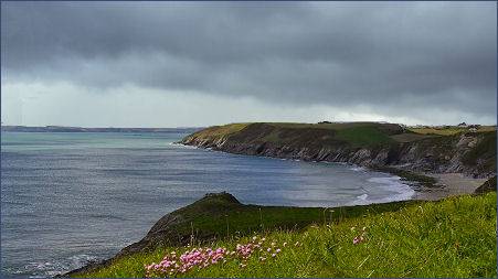 Peaceful Zone Point near the pretty village of St. Mawes forms the southernmost extremity of Cornwall's beautiful Roseland Peninsula, the point extends into Falmouth Bay.
Zone Point is situated around 500 metres (550 yards) eastsoutheast of St. Anthony's Lighthouse on St Anthony Head. The precarious cliffs render the beach between Zone Point and St Anthony Head inaccessible from the land and the small bay is the site of many Atlantic Grey Seal sightings. Atlantic Grey Seal pups can be sighted on this beach from the headland and the sea.
The top of Zone Point consists of pasture with scrubby slopes, it is rounded by the South West Coast Path and offers spectacular sea views over Nare Head and Dodman Point away to the east and over the Carrick Roads to Falmouth and St. Mawes.
The headland was once known as Zoze Point and was renamed during "corrective" mapping by the army in 1st World War.
A circular walk at Zone Point
Distance - 6.4 miles (10.4km)
Duration- 4hrs
(1) Commencing at St Anthony Head car park, from the far end of the car park go straight ahead along a lane passing the row of holiday cottages on your left. Continue along the coastal path to where it passing above Porthbeor Beach.
(2) Carry on along the coastal path round Porthmellin Head and Killigerran Head to arrive at Towan Beach. At the junction with the path heading down to the beach, turn left and head inland. Bear off left before reaching a gate and pass through a roofed passageway to arrive at a road. Cross the road and through a gapway, signed for 'Porth Farm', then go down a surfaced drive.
 (3) Enter the National Trust car park, then bear off left along a grassy path signposted 'Place via Percuil River'. Continue on crossing a footbridge, then turn right. Follow the edge of Froe Creek to a stile into woodland, then follow a path alongside Porth Creek and through Drawler Plantation, ignoring side paths to 'Bohortha'.
(4) Pass a small jetty and continue on to a kissing gate and onto the road end in front of Place House. Go left along the road and uphill. Turn right and cross a stile by a red gate, signposted 'Church of St Anthony and St Anthony Head'. Follow the path and ascend the steps opposite the church door and follow a shady path uphill.
(5) Bear right, then, at a T-junction with a track and turn right. Follow the track ahead and at the bend, bear off to the left. Cross a stile by a gate, then follow the edge of the field uphill. Cross over another stile, and keep straight ahead reaching the water's edge. Turn left and follow the coast path around Carricknath Point.
(6) Just past Great Molunan Beach, cross a causewayed dam above a small quay, then, at a junction, keep right and follow the coast path signs. At a junction with a surfaced track coming down from the left, keep straight ahead to St Anthony Lighthouse.
(7) Return to the junction and climb the steep, surfaced track to reach the car park. Halfway up, another track leads off right to the preserved Battery Observation Post and to the bird hide above Zone Point.