Castle-an-Dinas
OS grid ref:- SW 945 624
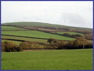 The Iron Age earthwork of Castle-an-Dinas is situated near to the village of St. Mawgan and stands 702 feet above sea level. The earthwork is generally thought to be one of the most significant hillforts in the British Isles. It is thought to have been occupied circa 400BC to 150 AD.
The castle consists of four large circular ramparts. Two Bronze Age barrows are set in the interior, the North barrow is now a hollow with a stone lying in it. Legend states that Castle an Dinas is the place where Gorlois, Duke of Cornwall and husband of King Arthur's mother died and was the hunting lodge of King Arthur, A stone at nearby St. Columb Major is said to bear the four footprints of King Arthur's horse made whilst hunting.
In March 1646, during the Civil War, Royalist troops under the command of Sir Ralph Hopton set up camp for two nights within the rings of the fort. A Council of War was held there where the decision to surrender to the Parliamentarians was reached. A few days later Hopton surrendered to General Thomas Fairfax, commander of the New Model Army, at Tresillian Bridge near Truro.
In June 1671, John Trehenban (16501671) of St Columb Major, commited the murder of two young girls, Anne Pollard and Loveday Rosevear in the home of Captain Peter Pollard and was sentenced to imprisonment in a cage on Castle an Dinas, were he was starved to death. Trehenban pretended to help find the murderer, riding on his horse following the bloodhounds, his hat blew off and the hounds refused to leave it. Eventually he confessed to the murder. He begged a passing woman for some food. All she had were a few tallow candles which he ate ravenously.
Castle-an-Dinas was the site of Cornwall's largest wolfram mine from 1917 to 1957, and many of the old buildings and workings are still standing.
 The site is reached via a footpath from the roadside. The inner circle is around sixteen hundred and fifty feet by fifteen hundred and occupies a commanding position. It has been owned by Cornwall Heritage Trust since 1988. The Trust have recently put up information boards at the car park and up towards the fort.
A panoramic plate was installed in the interior of the fort in June 2002, which amongst other local landmarks, points out the Nine Maidens Stone Row three miles to the North.
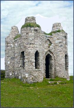
Roger's Folly (pictured right) stands on on the second ring of the ancient ramparts. The eighteenth century Gothic style tower was constructed in 1798 for John Rogers of Treassowe as a belvedere to enjoy the views across to St. Michael's Mount.
Directions
From the east - leave the A30 at the Victoria interchange and follow the old A30 through Victoria and under the iron bridge. This road swings t o the right across the new A30 and heads towards St Columb Major. As the road crests the hill, there is a signposted track to Castle-an- Dinas on the right. This track, along the edge of a field, leads to the southern edge of the site, where there is a small car park and an information plaque.
From the west- access is via the roundabout at the western end of St Columb Major on the A390. The hillfort is signposted from this point, l ying about a mile south of the roundabout. As the road crests the hill, there is a signposted tra ck to Castle-an-Dinas on the left. This track, along the edge of a field, leads to the southern edge of the site, where there is a small car park and an information plaque.