Trevelgue Head Cliff Castle
OS grid ref:- SW 825630
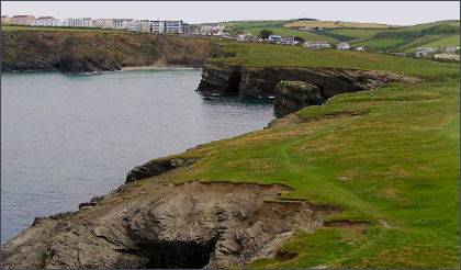
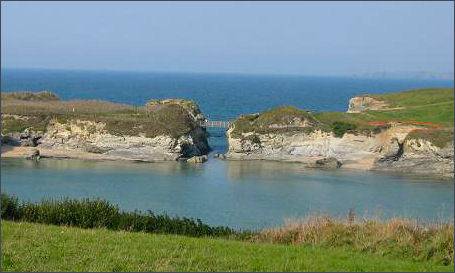 The spectacular promontory fort or cliff castle at Trevelgue Head, or Porth Island, just to the north of Newquay, is one of the finest ancient monuments in Cornwall.
Thje cliff castle consists of eight huge earth and stone ramparts, two large Early Bronze Age barrows and the foundations of several large and apparently unique roundhouses.
Trevelgue Head was once a long headland, today the main part of it is an island on which most of the site is located. A bridge links the island to the headland.
Trevelgue was subject to a major excavation directed by Charles Kenneth Croft Andrew in the summer of 1939, however the project was halted on the eve of the Second World War, work at the site ground to a halt, the team disbanded and the findings remained unpublished. Since 1997 English Heritage have funded a programme of full analysis of the principal finds.
 The excavations of the Iron Age coastal settlement have provided a wealth of information demonstrating Trevelgue's specialised character
in particular during the 1st millennium BC. The cliff castle has a long history going back to the Mesolithic period (over 7-8,000 years ago) but the main phase of activity associated with the appearance of the complex sets of ramparts, has now been radiocarbon dated to the 6th to 1st centuries BC.
The excavations of the Iron Age coastal settlement have provided a wealth of information demonstrating Trevelgue's specialised character
in particular during the 1st millennium BC. The cliff castle has a long history going back to the Mesolithic period (over 7-8,000 years ago) but the main phase of activity associated with the appearance of the complex sets of ramparts, has now been radiocarbon dated to the 6th to 1st centuries BC.
A large roundhouse stood at the centre of the fort, measuring 14.5 metres in diameter, it is unlikely to have been a domestic dwelling but rather a specialist structure which may have served as a meeting place. The remains of other roundhouses were found further up the slope set within aterraced field system. The interior of the unique roundhouse was examined alongside rich midden deposits and areas of industrial-working centred on iron smelting. The spectacular roundhouse of Iron Age date remains one of the largest buildings for this period discovered in Cornwall.
The excavations also revealed an area where iron smelting would have been carried out, features included furnaces and ore roasting pits. Metal objects of tin, copper and iron as well as some 200kg of iron slag were discovered. 600 items of worked stone were also excavated, these included quern fragments and a collection of spindles for spinning. Over 4,000 shards of highly decorated decorated pottery were unearthed many of which are now on display in the Royal Cornwall Museum in Truro. It is believed that the inhabitants of Trevelgue Head were members of the Celtic Dumnonii tribe.
A walk to Trevelgue Head from Newquay
Distance- 2.9 miles (4.6 km)
Duration- around 2hr 20min
(1) Commencing at Newquay Harbour procced to Towan Beach, continue in a north west direction along each of the Great Western, Tolcarne and Lusty Glaze beaches. Make sure you have left enough time to make the journey to Lusty Glaze before the tide comes in.
(2) On reaching the eastern end of Lusty Glaze Beach, take the steps to the road at the back of the beach and then up the steep steps to the road.
(3) Continue on the Coastal Footpath signed to Porth to reach Trevelgue Head. Retrace your steps to return to Newquay harbour.