The Eastern Islands
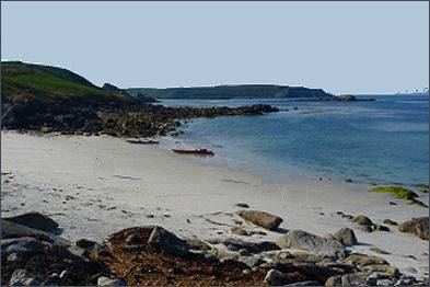 The starkly beautiful Eastern Isles are a group of twelve small uninhabited islands within the Isles of Scilly The islands lie to the south-east of St Martin's.
Known in Cornish as Enesow Goonhyli, which means the islands of the salt water downs, and are one of the best places for viewing the Atlantic Grey Seals as well as offering a wonderful variety of seabirds. The Bishop Rock Lighthouse is visible from the eastern-most Islands on a clear day. Most of the islands have dense cover of brambles, bracken and grassland along their coastal fringes with heather on the slopes. The islands are one of three main Grey Seal pupping areas, other mammals inhabiting the islands include Rabbits, Brown Rat, House Mouse and the Scilly Shrew.
The Eastern Islands are also home to breeding colonies of eight species of sea bird; including three species of gull, as well as the common shag (Phalacrocorax aristotelis), great cormorant (Phalacrocorax carbo), northern fulmar (Fulmarus glacialis), razorbill (Alca torda) and puffin (Fratercula arctica). Several of the isles are closed to visitors during the birds' breeding season (15 April to 20 August).
The St. Mary's Boatmen's Association offer a one and a half hour cruise around the group of islands Sailing from St. Mary's Quay, the trip lands at St. Martins.
Great and Little Ganilly
OS grid reference- SV 947 145The largest of the Eastern Isles, Great Ganilly has two hills connected by a low sandy neck. The northern of the two hills has the highest point at 34 metres (112 feet), a cairn stands on the summit of the hill providing evidence of past occupation in prehistoric times when the sea level around Scilly was higher and it was thought to form one much larger island. There is also a hut circle on the neck and the remains of field systems. A total of seventy-four plant species were recorded in the surveys of 1938 and 1939; the largest number of species on any of the Eastern Isles and includes Portland and sea spurge, sea-kale and balm-leaved figwort in the small sand dune system. Common thyme and orange bird's-foot grow on the heath, which is dominated by bell heather. Little Ganilly has several small caves on the east side.
Hanjague
OS grid reference- SV 957 150Hanjague is a sea stack which is situated around one km north east of Great Gannilly and next to Hard Lewis Rocks. It is the easternmost island in the Scilly archipelago. Known in Cornish as An Wynjek, meaning the windy one, te stack is used as a roost by seabirds.
Great, Middle and Little Arthur
OS grid reference- SV 942 137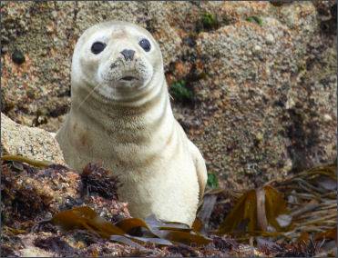 Known in Cornish as Ar Dhor, meaning facing land, the three rocky islands of Great, Middle and Little Arthur are joined by two beaches which form a crescent around Arthur Porth. A carn stands on top of the hill at Great Arthur which contains an entrance grave. The area of blown sand is dominated by marram grass which helps to stabilise the dunes. Middle Arthur has an entrance grave on the summit with a few patches of heather and some vegetation on the sheltered parts of its shore, Little Arthur has bracken and heather on its summit as well as stonecrop.
Menawethan
OS grid reference- SV 954 137The steep-sided island of Menawethan lies to the south-east of the Eastern Isles, a large tidal rock platform extends westwards from the island. A cairn dating from the Bronze Age cairn on the summit. Known in Cornish as Men an Wedhen, meaning the tree stone, it is home to breeding colonies of seabirds. Some areas of the island are covered in hottentot fig, which has probably carried there by gulls. Thrift and sea campion may also be found there. Grey seals are often sighted on its rocky shores.
Great Ganinick and Little Ganinick
OS grid reference SV 933 139Known in Cornish as Kenninek- place of wild garlic, the islands of Great Ganinick and Little Ganinick are the first of the Eastern Isles visitors see on the boat trips around the islands. They are in an early stage of linkage of two islands by a tombola or sand bar. Great Gannick possesses the only known oak tree in the Eastern Islands, thye stunted specimen stands about 2 feet 6 inches (0.76 m) tall and lies in tangle of bracken, bramble and honeysuckle. Great Gannick is rich in plant species including butcher's-broom, wood spurge, wood small-reed and white ramping-fumitory. Little Ganiinck, which is situated adjacent to Crow Sound, has grassland and has colonies of seabirds.
Nornour
OS grid reference SV 944 148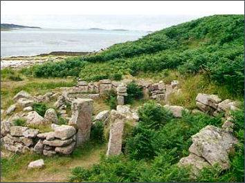 The tiny uninhabited island of Nornour covers 4 acres, the island consists of a bracken covered hill and is joined at low tide to the neighboring island of Great Ganilly by a boulder causeway.
Known in Cornish as Ar Nor, which means facing the mainland, the island was inhabited for a long period during the Bronze and Iron Ages through to the early Romano-British period when it would have have formed part of the much larger single island of Scilly. Due to rising sea levels the island became an archipelago. Nornour appears to have formerly been a hillock overlooking the main Roman port on the single main island of Insula Sillina.
A violent storm which occured in 1962 eroded the sand dunes at Nornour, uncovering an extensive settlement of ancient hut circles and a shrine to the goddess Sillina who is linked to Sulis of Bath. Each of the 11 dwellings had a main room with a smaller chamber alongside, with ramm floors, central hearths and courtyards.
Great Innisvouls and Little Innisvouls
OS grid reference - SV 953 141Known in Cornish as Enys Vols Meur, meaning great wether island, Great Innisvouls has a small area of grassland and bracken. Both islands have breeding seabirds and the Scilly Shrew has been recorded on Great Innisvouls. To the north-east of Little Innisvouls is a small rock called Mouls (grid reference - SV 957 144), where a nationally scarce pseudoscorpion, Neobisium maritimum was discovered in 1927.
Ragged Island
OS grid reference - SV 946 138Ragged Island, which has a length of 0.54 kilometres, is home two unexpected plants, Chilean hard-fern (Blechnum cordatum) and borage (Borago officinalis). How they got there remains a mystery, although Chilean hard-fern was recorded in Higher Town, St Martin's in 1936. Other plant species include thrift, scurvy grass, hastate orache and sea beet.
Guther's Island
OS grid reference - SV 918 144)The small island of Guther's is situated on the western side of the Eastern Isles and to the south of St Martin's. It has limited vegetation consisting of grass, docks and sea beet. Greater Black-backed and Herring Gulls are known to nest there as do Common Shags.
| Bryher Island | Eastern Islands | Gugh Island | Nornour Island |
| St. Agnes | St. Helen's | St. Martins | St. Mary's |
| Tresco |