St Mary's
OS grid reference :- SV 919 361
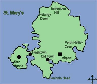 The stunning island of St. Mary's is the largest of the Isles of Scilly. Known in Cornish as Ennor, which means the mainland, the island spans 2½ miles in length and is 1¾ miles wide. Itr is home to about three quarters of the population of the Scilly Isles and possessing the island's only airport and docking point, St Mary's is the first island most visitors see.
The island's capital, Hugh Town (pictured left) is the main settlement on Scilly. Hugh Town main street is the main shopping area on the islands and business is reliant on tourism. Colourful pleasure launches regularly take passengers from St Mary's harbour for trips to the neighbouring islands of Tresco, Bryher, St Martin's, St Agnes and Samson.
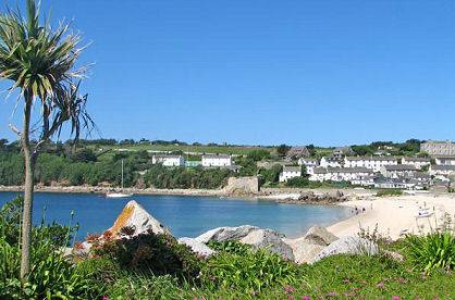 Known in Cornish as Tre Huw, the town lies on a narrow isthmus which joins the peninsula known as the Garrison with the rest of the island. There are are several beaches, banks, hotels, pubs and a small hospital.
The hamlet of Holy Vale is situated at the centre of the island. It is set in a secluded wooded valley which is about half an hours walk from the island's capital of Hugh Town. The hamlet's name was recorded as La Val in 1301, it derives from the Norman French meaning low lying, at the foot. Legend states that Holy Vale was once the site of a convent or monk's cell. The Isles of Scilly Wildlife Trust nature trail at Holy Vale is the largest wooded area on the island of St Mary's, which runs from the centre of the island, through Higher Moors and on to finish at Porth Hellick.
Old Town is believed to be the oldest settlement on the island of St. Mary's, many of its population moved to Hugh Town when Star Castle was constructed in 1593 to take advantage of the protection offered by the Garrison. Situated a short distance to the south of the island's capital, Hugh Town, the village has a church, an inn, the Old Town Inn, two cafes and a village store. It is a popular tourist area and is only a short distance from the island's airport. The village of Portloo lies about half a mile to the north of Hugh Town and is a popular tourist spot with hotels, guest houses and restaurants. The beach at Old Town is sandy, safe for swimming and easily accessed. The picturesque old church of St Mary dates from the twelfth century, with re-building carried out in 1666 and 1743.
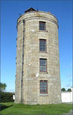 The Coastguard's Lookout Tower (pictured right) is also known as the Telegraph Tower is situated on the highest point on Scilly, from where there are stunning views over the entire archipelago and even as far as mainland Cornwall on a clear day. It was used by Radio Scilly for broadcasting. Dating from 1803, it was one of three gun towers built on St Mary's. It was at this tower about 1898 that Guglielmo Marconi heard wireless signals transmitted from Porthcurno, a distance of 30 miles.
 The subtropical garden of Carreg Dhu (Cornish for Black Rocks),
which covers 1.5 acres, is maintained by volunteers and entry is free. It is situated near Longstone Terrace in the centre of the island.
The subtropical garden of Carreg Dhu (Cornish for Black Rocks),
which covers 1.5 acres, is maintained by volunteers and entry is free. It is situated near Longstone Terrace in the centre of the island.
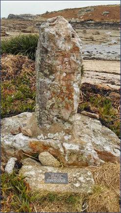
Porth Hellick Bay is situated on the south coast of the Island. At Porthellick Cove stands a memorial to mark the site where the body of Admiral Sir Cloudesley Shovell was washed ashore at St. Mary's (pictured left) following the 1707 Scilly naval disaster. This was one of the greatest maritime disasters in English history, when four ships, Association, Firebrand, Romney and Eagle were lost and nearly 2,000 sailors perished. Shovell was temporarily buried on the beach and although he was largely responsible for the disaster, by order of Queen Anne his body was later exhumed, embalmed and taken to London where he was interred in Westminster Abbey.
Evidence of St Mary's long past can be seen in many of the historic buildings on the island, from Neolithic chamber tombs to Civil War fortifications.
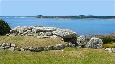
There is evidence of extensive settlement on the Isles of Scilly from around 2500 BC. At that time the sea level was lower and much of Scilly formed a single landmass. Bant's Carn, (below right) an entrance grave dating from the Bronze Age is situated on the island of St Mary's and an Iron Age/Romano-British village at Halangy Down. Excavations of the site took place in the 1950s and revealed a complex of 11 inter-connecting stone-built houses, many of them simple oval structures which probably had a conical thatched roof. Stone-lined drains, hearths and cupboards constructed from the thickness of the walls were uncovered.
Innisidgen Hill to the north east of Hugh Town on St. Mary's is the location of two chambered tombs or entrance graves dating from the Bronze Age which were excavated in 1854. The burial chambers overlook the Crow sound with views towards the Eastern Isles. Entrance graves are sometimes referred to as Scillonian tombs due to their concentration on the Isles of Scilly although a few survive on the Penwith peninsula of west Cornwall
 Harry's Walls, the remains of an unfinished artillery castle, are situated on a hilltop to the north-east of Hugh Town. The fort was constructed in 1551 as part of a major phase of fortification on the Islands, designed to counter threats from the French. It was left unfinished because the site was recognised to be unsuitable.
Star Castle is at the centre of a fortification system around the west side of St Mary's known locally as the Garrison. The walls of the castle take the shape of an eight-pointed star. The Star Castle was constructed by mapmaker and Surveyor of the Royal Works, Robert Adams, under the direction of Sir Francis Godolphin, Captain of the Scilly Isles, in the reign of Queen Elizabeth I, following the Spanish Armada of 1588.
The wild and rugged promontory of Peninnis Head, a designated Site of Special Scientific Interest (SSSI) is littered with granite rocks and boulders which have been eroded by the action of the wind and pounding waves into fantastic shapes. These include the rock formation known as the Kettle and Pans, which lies around 100 yards north of Peninnis Lighthouse, where immense basins have been hollowed out by the elements
| Bryher Island | Eastern Islands | Gugh Island | Nornour Island |
| St. Agnes | St. Helen's | St. Martins | St. Mary's |
| Tresco |