Gugh
OS grid reference :- SV 888085
 The tiny island of Gugh on the Isles of Scilly archipeligo is only truly an island at times of high tide, as it is joined to the island of St. Agnes by a tombolo or sandbar, known as the Gugh Bar, which is exposed at low tide. The two islands together have the smallest population of the Isles of Scilly.
 Gugh, which is known in Cornish as Keow, meaning hedge banks, lies within the Isles of Scilly Heritage Coast, and is managed by the Isles of Scilly Wildlife Trust.
The island has just 2 houses on its shores, built in the 1920's and is only one kilometre in length and about 0.5 kilometre wide, there is a coastal path running round most of Gugh, a walk around the perimeter of the island only takes about 40 minutes. There are a few other paths that cross the width of the island.
The earliest signs of human habitation on Gugh consist of two groups of entrance graves and cairns which have been found to date to the late Neolithic or early Bronze Age periods. Five entrance graves stand on Kittern Hill, at the north of the island. One of these, Obadiah's Barrow, was excavated in 1901 by the archaeologist George Bonsor, and "disarticulate burnt bones" were discovered, the barrow was so named for Obadiah Hicks of St Agnes with whom Bonsor was staying. There is also a cluster of fourteen cairns which are linked by prehistoric field walls or banks.
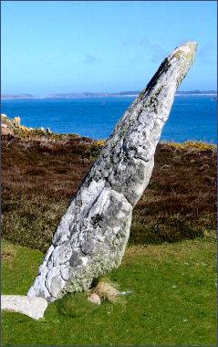
 The menhir known as the Old Man of Gugh, (pictured right) lies at the base of Kittern Hill stands around 3 metres high and is thought to be associated with Bronze Age rituals, The Old Man of Gugh is the only menhir in the Scillies to have yet been excavated, excavations carried out at at the monument failed to unearth any features or finds.
Kittern Hill shows evidence of prehistoric dwellings and tombs including Obadiah's Barrow as well as remains of ancient field walls. Obadiah's Barrow was excavated by archaeologist George Bonsor in 1901 when it was found to contain the remains of a contracted male skeleton, and a dozen cremation urns.
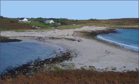
Idyllic Dropnose Point lies on the east coast of Gugh, near St. Agnes with views across St Mary's Sound to the largest island of St Mary's. The secluded beach has vanilla coloured sand and is sheltered by Carn Kimbra to the north and Dropnose Point to the south.
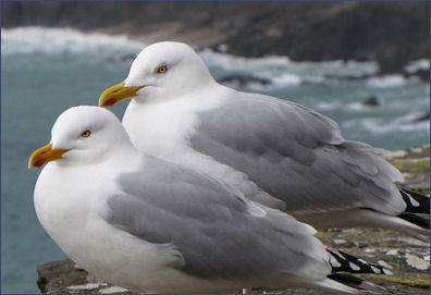
Vegetation on Gugh, sometimes known as The Gugh, mainly consists of wind-pruned heath and dense bracken and bramble with a small area of coastal grassland formed over blown sand which has accumulated near Gugh Bar. The southern part of the island is home to large colonies of lesser-black-blacked (Larus fuscus graellsii) and herring gull (Larus argentatus), a small number of greater black-backed gull (Larus marinus) also breed there.
| Bryher Island | Eastern Islands | Gugh Island | Nornour Island |
| St. Agnes | St. Helen's | St. Martins | St. Mary's |
| Tresco |