Harry's Walls, St. Mary's
OS grid reference :- SV 909 108
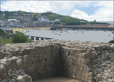 Harry's Walls are the remains of an unfinished artillery fort, built above St Mary's Pool and Hugh Town.
King Henry VIII's break with Rome and establishment of the Church of England made the south coast vulnerable to attack from Catholic France and Spain. Henry reacted to this threat by ordering the construction of of a chain of artillery forts and blockhouses to guard the harbours and beaches of southern England. The building of Harry's walls at St. Mary's began in 1551 by the government of Henry's son and successor, the boy king Edward VI, but was abandoned because of the unsuitable siting.
The intended completed fort was probably the first use of an Italian model, based on the increasing use of cannon, to be built in England. Only a small part of the fort had been built before it was abandoned. To operate effectively, a fort needed to command a wide field of fire for its own guns, while affording protection against enemy guns. Although Harry's Walls occupies high ground, it swiftly became apparent that it was not situated in the best position from which to prevent an attack on St. Mary's Harbour. The headland around the west side of St. Mary's, now known as The Garrison presented a better location, and was eventually chosen as the site of the islands' principal fortress.
The remaining curtain wall measures 27 metres long, the average height inside the curtain wall is 1 metre. The curtain and bastion wall faces have now been largely robbed of their granite blocks. A mill and brewhouse were to be built by the freshwater pond below the hill. The passage way leading from the bastion to the courtyard is well preserved, but the one at the west bastion has been badly damaged. A trench marks the intended line of the north-west curtain wall.