Bude
OS Grid ref:- SS215065
 The attractive town of Bude, situated at the mouth of the River Neet, in the far north of Cornwall, the town stands on Cornwall's border with Devon and has an exceptionally mild climate.
Bude, known in Cornish as Porthbud, is described as "the liveliest peace of Cornwall" and is a major surfing resort, boasting some of the best surfing beaches in Britain, including Summerleaze Beach, attended throughout the summer by a lifeguard. Crooklets and 'middle' beaches are both also within the town.
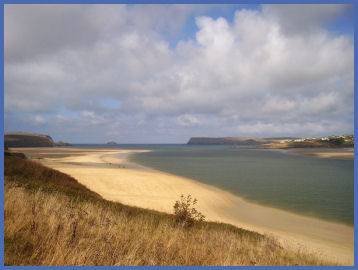
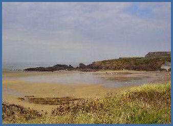
Widemouth Bay lies a few miles south of the town and offers a long, wide sandy beach. Sandymouth Beach is owned by the National Trust, and has spectacular cliffs and rock formations with shingle below the cliffs and a large expanse of sand at low tide. There are also a number of other coves and beaches to be found and explored in the local area, surrounded by a spectacular Heritage Coastline. Bude Coast SSSI (Site of Special Scientific Interest), located between Compass Cove to the south and Furzey Cove to the north, is noted for its geological and biological interest
 The town of Bude boasts a rich and colourful history. The name is of medieval origin, when Bude was little more than a chapel on a rock.The rock on which the chapel stood is now part of the breakwater and still bears the name "Chapel Rock". By the eightenth century Bude had developed into a thriving port,
its popularity as a seaside resort dates from Victorian times.
The town of Bude boasts a rich and colourful history. The name is of medieval origin, when Bude was little more than a chapel on a rock.The rock on which the chapel stood is now part of the breakwater and still bears the name "Chapel Rock". By the eightenth century Bude had developed into a thriving port,
its popularity as a seaside resort dates from Victorian times.
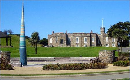
Bude Castle, a castellated manor house which overlooks the town, occupies a hill near Summerleaze Beach and dates from the 1830's. It was built by the inventor Sir Goldworthy Gurney to prove that a house could be built on sand with the use of a concrete raft. The Castle now hosts a Heritage Centre which features the fascinating natural history and world famous geology of the north Cornish Coast. from its surf to rock pools and grand cliff-top panoramas.Three figureheads of locally wrecked ships are on display, together with a Rocket Brigade pistol, Breeches Buoy and a multi-media display of some the stricken vessels. There is a display about Budes most famous wreck, that of the Bencoolen in 1862. She was wrecked on Summerleaze beach which the Castle overlooks.
Other buildings of interest include the Perpendicular medieval parish church of St Olaf's in the village of Poughill just outside Bude; the parish church of St Michael and All Angels, which was built in 1835 and enlarged in 1876, Quay Cottage in the centre of the town and Ebbingford Manor, the town's oldest house which is said to have the smallest chapel in England. The first recorded mention of Ebbingford dates from 1183, In 1433 the Manor passed into hands of the influential Arundell family has a number of literary connections.
 In addition, Bude offers opportunities for golfing, bird watching and cycling, and a wide range of accomodation and shops. The town has a seawater swimming pool under Summerleaze Downs, as well as a heated leisure pool with wave machine, flume and cafe. Near to the beach are a laser dome, trampolines, putting and tennis courts.
At the northernmost point of Efford Down Farm, overlooking Summerleaze Beach and the breakwater, stands a former coastguard lookout. Known as Compass Point, it was built by the wealthy Acland family in 1840 and is based on the Temple of Winds in Athens. It was moved to its current position in 1880. It derives its name from the fact that it has points of the compass carved in each of its octagonal sides
Bude canal, built by Sir Thomas Acland in 1926, is almost unique in England, it was not primarily constructed to transport goods to the Cornish coast, but to carry large quantities of sand inland to improve the acid soil. Today the sea lock is still in working order, although, it is the only lock on this section still in working order, so that navigation is not possible along the whole network
The two mile tow path along the Bude Canal makes a pleasant walk.
A walk at Bude Canal
Distance - 5 miles
Duration - 2 - 2.5 hours
*Commencing at Bude Visitor Centre proceed along the canal towpath inland until reaching Whalesborough Wood. Turn left at Hele Bridge and cross the bridge to join a footpath.
*Follow the canal towpath toward Marhamchurch, on reaching a pumping station take the lane to the left, crossing a river. Turn right toward Hele Mill, turning left before the mill and ascend steps to join a footpath. A gate on the right of the upper half of the field leads to an old road.
*Turn left after passing a farnhouse to a gateway which offers stunning views of the Bude Valley, retrace your steps past the houses and turn left. Cross the A39 road/ Continue until the track joins an old railway. Continue along the railway for a short distance turning left down embankment steps upon reaching them, to join a fenced path.
*Turn left at the road by the railway bridge. Cross the field on your right. The road then leads to Rodd's Bridge and Bude.
Map:- Landranger Series 190: Bude Clovelly and surrounding area.