Port Quin
OS Grid ref:- SW 971806
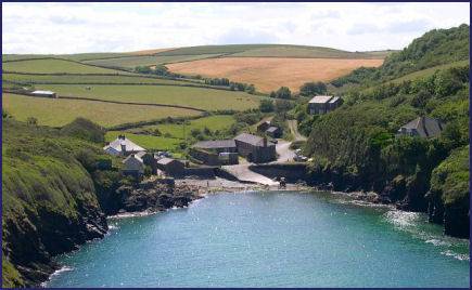 The small, pretty harbour of Port Quin is situated a few miles to the south of the vilage of Port Isaac. The name is thought to derive from the Cornish 'Porth' meaning harbour and 'gwynn' meaning white.
The harbour is set in a tranquil cove, the only buildings being four National Trust holiday cottages. The 1841 census reveals the village once had a population of 94 living in 23 different homes. The harbour sent its own ships to Wales during the late mediaeval period, trading coal, lead and even granite.
Local folklore relates that in the nineteenth century Port Quin's fishing fleet was lost at sea during the course of a wild and stormy winter night, no survivors were ever found. The women of the village struggled to carry on alone but, eventually were forced by hardship to abandon the village. The story gave rise to Port Quin's nickname - 'The village that died.'. The picturesque cove never recovered from the disaster, and today it is home to just four cottages, all owned by the National Trust and available as holiday lets, and a couple of converted stone fish warehouses.
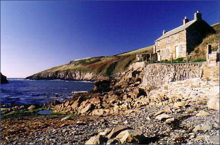 The truncated Gothic tower of Doyden Castle, which stands on the headland to the south of Port Quin began life in 1830 as a retreat for a Wadebridge businessman, Samuel Symons, as a place to entertain his friends, where they spent their time drinking and gambling. Doyden Castle is now owned by the National Trust. The building was used in the television series Poldark.
The South West Coast Path passes through Doyden Point, a long-disused mine, known as Gilson's Cove mine or Doyden Point mine, produced sliver-lead and, it is believed, a little copper.
A short walk from Doyden Point leads to Lundy Bay, a protected area of costal land that is home to to many species of birds. The main claim to fame for the area is the Lundy Hole, a collapsed sea cave just to the west of the beach. Scoured out by the action of the waves, which widened and deepened a line of natural weakness in the bed rock. Eventually the cave roof collapsed leaving a deep pit and natural arch. This is one of a series of sea caves and other natural erosion features that can be seen along this stretch of coast.
There is a viewing area above Lundy Hole. Local legend states it was made by the Devil while he was pursuing St Minver. Care should be exercised when visiting the site.
Image copyright Tony Atkin
A walk from Port Quin to Port Isaac
Distance around 3 miles
*Commencing at the Castle Rock Car Park at Port Isaac, head towards the sea to meet with the coastal path, pass the beach and harbour and turn right climbing .Roscarrock Hill to reach a group of houses.
* At the Pine Haven signpost proceed up the valley floor and away from the sea. Cross a slate stile and bear right, on reaching a further stile cross into a field and continue along the right hand field boundary. On reaching a set of farmgates bear right and continue down the track.
*Cross a stile and keep to the left field boundary. Cross a further stile and proceed through a field. Cross yet another stile and arrive at a road.
*Continue along the road to reach Port Quin.
*Retrace your steps to return.