St. Breock
OS Grid ref:- SW 977 717
 The pleasant village of St Breock is situated around a mile (1.6 km) to the west of Wadebridge and lies on the eastern slope of the wooded Nansent valley. It is known in Cornish as Nansant meaning Holy Valley.
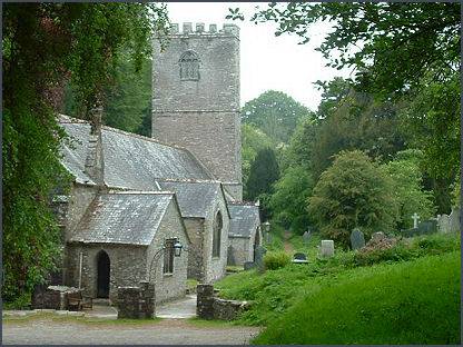
The beautiful village church is dedicated to St Briocus and dates back to the thirteenth century although it was extensively rebuilt in 1677. All that now remains of the thirteenth century structure are parts of the tower, the walls at the west end and possibly part of the wall to the right of the High Altar. The building is situated beside the stream in the valley bottom and consequently, in 1965, suffered damage in a major flood. The church contains some interesting monuments to members of the Tredenecks, a well established local family. John Tredeneck who died 1566, was an MP in the Reformation Parliament.
St Briocus was a native of Cardiganshire, who was educated in France by St. Germanus. He returned to his native Britain, where he converted his parents with others to Christianity. Returning to France, he settled in Brittany and founded the great monastery which bears his name, where he died in his ninetieth year.
The area today is known as St Breock appeared in the Domesday Book of 1086 as part of Pawton. The ancient Manor of Pawton was established in Saxon times. It was granted to the Bishops of Sherborne by King Egbert of Wessex and held by their successors until it was alienated under Henry VIII. In 1086 there were 44 hides of land, land for 60 ploughs, 40 villagers and 40 smallholders; pasture 12 sq leagues, woodland 2 sq leagues.
At Nanscowe Farm stands a pillar stone dating to the fifth or sixth century with a Latin inscription which translates as 'To the son of Ulcagnus; and to Severus'.
St Breock Downs Monolith
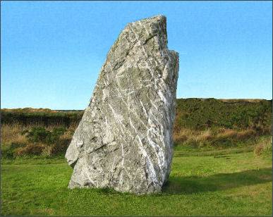 Cornwall's largest and heaviest prehistoric monument, the St Breock Downs Monolith originally stood at 5 metres (16 feet) in height and weighs some 16.75 tons. The monolith stands at the summit of St Breock Downs, from were there are superb views of the surrounding countryside and across to the sea.
The monument, also known as the St Breock Longstone or Men Gurta, stands within a low stone mound or cairn, which measures about 33 feet (10 metres) across. It is formed from the local Devonian shale which has extensive feldspar veining. It is thought to date to the Late Neolithic to mid-Bronze Age eras (around 2500-1500 BC).
The stone fell in 1945, but was re-erected in 1956 after a small excavation had been carried out. This revealed that it stood in a setting of quartz pebbles below which were two small, shallow hollows.
The area around the St Breock Downs Monolith contains many other Bronze Age ritual monuments, with which the stone was probably associated. These include at least one other standing stone, and a series of barrows that extend up to 4 miles (7km) to the west.