Gribbin Head
Os Grid ref:- SX124514
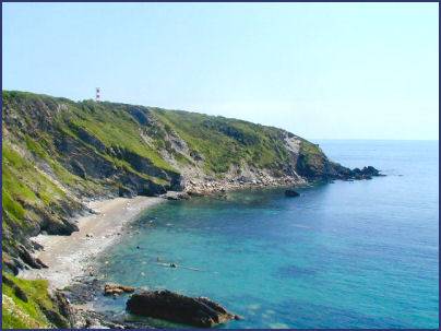 The dramatic green headland of Gribbin Head on the Polperro Heritage Coast makes a
rewarding walk from Fowey, or from the car park south of Polkerris. The headland offers some superb sea views.
The dramatic green headland of Gribbin Head on the Polperro Heritage Coast makes a
rewarding walk from Fowey, or from the car park south of Polkerris. The headland offers some superb sea views.
Gribbin Head, referred to locally as 'the Gribbin', separates the harbours of Par and Fowey , the distinctive red and white striped day navigation beacon, the Daymark Tower which perches at the top of the headland was erected in 1832 as a safety measure. Sailors often mistook Gribbin Head for St. Anthony's Head at the entrance of Falmouth Estuary. Many accidents resulted from the confusion until the Daymark Tower was built to distinguish the two headlands.
The South West Coast Path, which traverses the headland, is the longest of England's national trails, running for six hundred miles from Minehead on the edge of the beautiful Exmoor National Park, to the shores of Poole Harbour in Dorset. The path is an excellent way to see Cornwall's superb coastal scenery, wildlife and unique heritage. In its Cornwall section the path traverses a variety of scenery, cliffs, secluded coves, and awe inspiring rock stacks
Gribbin Head is currently owned by the National Trust. The Trust organises regular open days during the summer months when visitors can climb to the top of the 84 (25.4 metres) feet high Daymark Tower, which offers superb views of the dramatic Cornish coastline.
The famous Cornish author Daphne du Maurier (1907 - 89) who wrote 'Jamaicia Inn and 'The Birds' lived for many years at Menabilly at Gribbin Head, a seventeenth century mansion overlooking the sea, once belonging to the Rashleigh family.
Daphne du Maurier used the house as a model for Manderley in one of her most popular novels 'Rebecca', the Manderley featured in the novel, and in the novels 'My Cousin Rachel' and 'The King's General'. Daphne Du Maurier moved into the house in 1943 and lived there until 1969 when the lease expired on the house.
Image 1 copyright Chris J Dixon
A walk to Gribbin Head from Polkerris
 Distance - around 8 miles
*Commencing at the car park in Polkerris, proceed downhill walking toward the sea. Before arriving at the beach fork left and then again left by a black and white building proceed up the path to emerge onto a road.
*Turn right and walk along the road until reaching a waymarked path to Tregaminion Farm. Pass the farm and cross fields to arrive at Trenant from where folow waymarks to Menabilly Wood.
*Follow the path through the wood, passing under a bridge, cross stepping stones and ascend from the valley to arrive at Lankelly Farm.
* Emerge onto a lane and turn right, on reaching a junction continue straight on. At the second junction turn left. Turn right on reaching Love Lane and continue down to Readymoney Cove.
*Exit the Cove via the coastal path and ascend to St Catherine's Point w. Continue to follow the coastal path along the cliffs to Gribbin Head.
*Retrace your steps to return to Polkerris.