Brown Willy
OS Grid ref:-
 The curious name of Brown Willy derives from the Cornish Bronn Wennili, which means 'hill of swallows'. The first part of the hill's name is a common Brythonic element meaning "breast, pap; hill-side, slope, breast (of hill)", which also occurs frequently in Welsh placenames. It is recorded as Brunwenely in the twelfth century. In recent years a campaign has been launched to have the name of a landmark on Bodmin Moor in Cornwall officially changed to its original Cornish title.
Brown Willy lies around 2.5 miles (4.0 km) north-west of the village of Bolventor, made famous by Daphne du Maurier's 1936 novel of the same name. The summit of the hill, which at 1,378 feet (420 m) above sea level, is the highest point of Bodmin Moor and of Cornwall, is situated as round the middle of the long thin ridge, from which the Westcountry peninsula may be viewed.
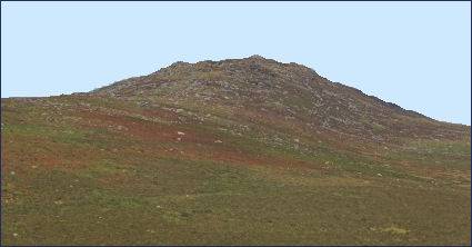
The hill has the conical appearance of a sugarloaf from the north but widens into a long multi-peaked crest from closer range. The summit of the hill, which rises to 1,378 feet (420 m) above sea level, is the highest point on great boggy expanse of Bodmin Moor and of all Cornwall. On a clear day views from the summit include Tintagel in the north and the China clay hills around St Austell to the south. The surounding terrain is typical of Bodmin Moor, with rocky outcrops ("tors") surrounded by bleak and desolate moorland. Streams and marshes are common surrounding the summit. The second highest point in the county is nearby Rough Tor which rises to 1,313 feet (400m).
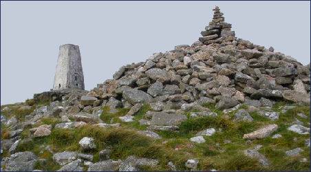
Naturally-occurring piles of granite boulders lie around the summit, one of these, known as the Cheesewring is curiously composed of 5 separate rocks which get larger towards the top.
There are two man-made cairns on the summit of the hill. Brown Willy Summit Cairn or Brown Willy North Cairn (pictured right) is a man made rock pile that stands alongside an Ordnance Survey triangulation station.
Brown Willy is known for a meteorological phenomenon which is known as the Brown Willy effect, in which heavy rain develops over high ground then proceeds downwind for a long distance. The effect produces very heavy localised rain which can cause disastrous flash flooding such as the Boscastle flood of 2004. In another case when the effect was manifested, a continuous line of showers developed on 27 March 2006 stretching 145 miles from Brown Willy to Oxfordshire.
A walk to the summit of Brown Willy from Camelford
Length of walk- 4 miles (6.5km)
Head southeast from Camelford to the Poldue Downs, where car parking is provided. From the car park follow the path to the summit of Rough Tor. Halfway to the summit, leave the main path, taking the west track up to Showery Tor, the summit at the west edge of the ridge. As the crest of the ridge is reached Brown Willy will come into view.
*Avoid walking on the moor if weather looks threatening.
*A compass is required for walking on the moor in case the mist descends.
*Carry light waterproof clothing.
*Wear headwear if walking in winter.
*Keep dogs under control, ponies, sheep and cattle graze on the moor.