Minions
OS Grid ref:- SX2671
 The village of Minions, known in the Cornish language as Menyon, lies around four miles (6 km) north of the town of Liskeard on brooding Bodmin Moor.
Minions holds the distinction of being the highest village in Cornwall, being situated 300 metres above sea level. the curious name derives from nearby Minions Mound, a barrow which lies just to the west. The village boasts a pub, the Cheesewing, a post office and shop, tearooms and a restaurant.
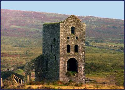
Minions came into being to serve the needs of the three major activities of mining, quarrying and the railways and was constructed between 1863 and 1880. Unique in Cornwall, it was created on a totally virgin moorland site. Tin and Copper Mining ceased in the early twentieth century, the last mine to operate being the Prince of Wales Shaft, which closed in around 1914. Many of the mine pump houses still litter the moorland landscape.
One of the Engine Houses which once belonged to the South Phoenix Mine has been converted into The Minions Heritage Centre. The Centre interprets the history of the landscape from the Stone Age, through the eighteenth and nineteenth century mining, to the present day and is open all year round, admission is free.
 Quarrying also provided employment around Minions in the nineteenth century and there are several quarries in the area. The products of the mines and quarries was transported to Liskeard and then onto Looe for shipping, on the Liskeard & Caradon Railway which was constructed around 1844.
The moorland track which runs from Minions makes an rewarding short stroll, its route passes the Hurlers and the Cheesewring, a strangely shaped granite outcrop, from which the village pub derives its name. The feature, with its strange balancing rocks, perches on Stowes Hill and is believed to have been formed over thousands of years by glaciation and erosion.
A cave within the Cheesewring was once the home of an eccentric eighteenth century Cornishman, Daniel Gumb and his family. The views from the summit, which stretch across Cornwall into Devon on a clear day, are superb.
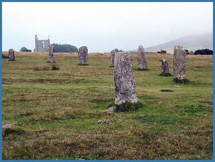
The atmospheric moorland around Minions offers a wealth of prehistoric remains. The three stone circles known as the Hurlers (OS grid ref- SX259714, pictured right) stands close to the village, the circles are one of the largest prehistoric sites in England. The three stone circles stand close together and all in a line running NNE to SSW. .
The circles are believed to date from the Bronze Age. Many people have speculated on the purpose of the circles from astronomical clock to a ritual meeting place. Multiple stone circles are not uncommon in the south-west area of England. One of the largest prehistoric sites in England, the three stone circles stand close together and all in a line running NNE to SSW. Local legend states that the Hurlers are the forms of men turned to stone for playing the game of hurlers on the Sabbath.
Rilaton Barrow
 A line drawn through the centres of the circles points to Rillaton Barrow, a large prehistoric burial mound, which stands five hundred metres north-northeast of the Hurlers.
The barrow consists of a mound of stone and earth that has a diameter of over 35 metres and stands over 2.5 metres high. There is a slab lined cist on its eastern side which is aligned north-south and measures about 2 metres long.
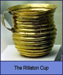
In 1837 and a gold, corrugated cup, now known as the Rillaton Cup, a bronze dagger, beads, pottery, glass and other items were excavated from the barrow. The cup was handed over as treasure trove to King William IV, and found its way into King George V's dressing room where he is said to have used it for storing collar studs!
The cup resembles a late Neolithic (approx 2300 BC) ceramic beaker with corded decoration and is believed to date from 2000-1500BC. Theories that it may have been deposited as a votive offering have now been abandoned in favour of it being part of the original grave goods in the Ringlemere barrow.
The Rilaton Cup is now kept in the British Museum. A replica of the cup may be seen in the Royal Cornwall Museum at Truro.
The towns and villages of Cornwall