Stannon Stone Circle
OS grid ref:- SX126800
 Stannon Stone Circle is situated near the village of St. Breward on Bodmin Moor, and stands on Dinnever Hill, two and a half miles to the southeast of Camelford.
There are several stone circles on Bodmin Moor, including The Hurlers, the Trippet Stones, Stripple Strones and Fernacre. The Stannon Stone Circle derives its name from the nearby Stannon Farm and is sited between two streams. It is overlooked on one side by a huge china clay works.
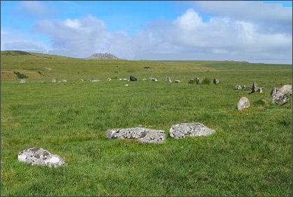
It consists of 47 upright stones, 30 recumbent and 2 displaced within an impressive 42.6 metres (140 feet) by 40.5 metres (133 feet) metre flattened circle with four outlying stones. As with most circles on this part of Bodmin moor, the largest and most significant stones are triangular in shape, pointing upwards. The stones average size is 1.6 feet and are closely spaced. The circle dates from either the late Neolithic or early Bronze Age. It has been contended that Stannon is earlier in date than other circles in the southern area of the moors such as the Stripple Stones.
Around 80 metres to the northwest of the circle stands a small line of four stones, two of which have very pointed tops.
Excavations were carried out in the area of Stannon Down by the archaeologist R. J. Mercer in the late 1960s. He examined eight unenclosed round house sites that were suggested to be a settlement of over twenty, with fields for farming along with rectangular enclosures tentatively identified as corrals. His investigations revealed that the area would have been near to mixed oak woodlands and oaks would have grown in the area that would probably have been cleared in the first phases of settlement. Houses were constructed of posts, supporting thatched roofs, and incorporated drainage and furniture. Pottery and flint tools were discovered along with a whetstone that suggested the possibility of metal blades. The settlement was estimated to have a population of around one hundred people and dated to the Middle Bronze Age.
Directions
Turn off the B3266 road at the track towards Stannon china clay tips. The circle lies not far from track.